Our task for the day was to drive a mere 389 km from Birdsville to Windorah, not a long way. Progress initially was slow with further horrendous corrugations and driving outside the guide posts:

During the day the only wildlife we saw was a few emus:


An hour and three quarters into our journey we reached the rainbow serpent artwork on the hillside near Betoota, made using the different types of gravel and gibbers found in the shire.

It was hard to photograph because it was west-facing with the sun to the east. The above photo was taken by Darral the previous day shortly after midday when the sun was starting to come around.
Betoota itself is a few kilometres off the road. It consists of a single abandoned pub:

The sign told us, population 0 and elevation 70 metres:

My great passion is the science and politics of climate change. I was startled to realise that if all the ice sheets melt, as they will do in a few millennia if we remain on our current trajectory, then Betoota will be under the sea! This map from David Spratt, a science writer who inhabits the site Climate Code Red, shows most of the Simpson Desert disappearing beneath the waves:

Sorry about that jarring note. Being mugged by reality can be sobering! Betoota itself died in 1997 when the new road bypassed the pub. The main building is still quite sound:

The associated structures are frozen in time and still in reasonable shape apart from some rust:


Len inspected the toilets:

What he found was a ‘long-drop thunder-box’ of a type that was common in the bush in years gone by!

Margot observed him emerging:

The Betoota Racetrack which hosts the famous Channel Country Ladies Day Festival was visible on the horizon. We gave it a miss.
A bit further down the road we diverted to a lookout, with a shelter, a toilet and a monument paying tribute to a young man who had died in a helicopter accident in the district:


The lookout was memorable for the wind, the expansive views and a toilet door that would not shut when you were inside:


Soon we found the roadworks in progress:

Impressive!
There were a few strips of bitumen which doubled as an aircraft runway:

We were on the wrong side of the road and flat out as Len put his foot down to pass a road-train before we ran out of bitumen. Margot did well to catch the markings at 140 kph. Please note, she was in the front seat!
As we travelled eastwards the quality of the country improved and the wide-spread drought eased a little. These cattle were in quite good shape:

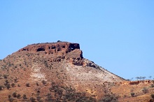
Two hills appeared on the right:

If you stood near the sign you could see a hole in one of them. The problem was trying to take a photo with the zoom lens while swaying in the strong wind. Margot shot the sky, I shot the side of the mountain. Here I’m leaning on the sign for support, itself swaying in the breeze, with Margot trying to steady me:

Eventually I got the bullseye, albeit poorly focussed:

Len being a man of substance and clever with his hands had no trouble with this slightly less ambitious shot:

We came upon a feature which is thought to have been a native well:


It’s not strictly true that Big Red was the last sandhill. There were occasional sandhills right up until a few kilometres west of Windorah:

Eventually we came to Windorah, a tidy, well-kept little town with a population of 158, main centre of the Barcoo Shire, population 346. When local government was restructured and consolidated by the Beattie government they left these western shires alone.
After buying a loaf of bread, (found in the freezer in these small western towns), we had a late lunch in a pleasant park. This was the the first food we had bought since leaving Alice Springs.


We had hoped to undertake a tourist drive around a bit of the Channel Country, but were advised it was too wet. They’d just had 27 mm of rain. Instead we took a look at the local museum:


That spider was plastic!
A message on a Super Shelltox can advised that the spray, consisting of pyrethrum and DDT, was “harmless to humans” “when used in accordance with directions”:


Near a main junction in the road was the dinkiest little house. Most of the time we were in town, there was an old-timer sitting in one of those comfy arm-chairs:

On our way to the Cooper’s Creek crossing, where we planned to camp, we passed what might be termed a small, large-scale (as opposed to roof-top) solar array:

The solar farm saves 100,000 litres of diesel each year and was commissioned in 2009. At times some dishes are parked, depending on the town’s electricity requirements. Each dish consists of 112 mirrors focussing sunlight on small central ‘satellite-quality’ photovoltaic cells.
That photo was actually taken by Marion the day before. Notice the pooled water.
Next post, camping at Cooper’s Creek and ‘home’ to Emerald.
Note: This post is the twelfth in a series on our Red Centre holiday.
There was a Landline episode about the Channel Country Ladies day. Those women deserve a day out! Many still bake bread and cook for tribes of people.
Some years ago we took a flight over this area when the water was coming down the channels. Amazing to see.
It has already been under the sea so if it goes under again in a few millenia, so what!
Thanks Brian for a great tour of this amazing part of the country.
That country women’s day is a magnificent event. I’ve seen that documentary twice. Very warming to see women getting to be girls and enjoy each others company. I would like to see that channel country in action with the water flowing, from the air. It is definitely on my bucket list.
Whereas I really do appreciate seeing the Simpson desert at ground level in image form, I have no desire to follow in Brian’s foot steps, other than by way of a few touch downs in a flyover. My primal instincts guide me to not stray too far from large bodies of water.
Lorna @ 1, no problems!
On sea levels, I’d say this. It was about 15 million years ago when the ice sheets last almost melted. Other than that you have to go back about 40 million years. Hominids started their journey about 6 million years ago and homo sapiens about 200,000.
The real story is the last 8 to 10,000 years when we invented agriculture and started swarming. During this time sea levels have really been very stable and conditions have suited us. Now arguably in plague proportions we will find it difficult to cope with being progressively displaced. 150,000 with one metre and it goes on from there to reach several billions. From the second half of this century we will have unstable shorelines.
Of course all that won’t happen. We’ll come to our senses and do something about it, won’t we?