Back in November 2010 I did a post on Climate change and the Murray Darling Basin at a time when a plan for the Basin was proposed, but not yet settled. The post still gets a steady trickle of visitors.
The Murray Darling Basin Plan was passed into law in November 2012, when Julia Gillard was prime minister, and Tony Burke the minister responsible. There has been a recent kerfuffle, when Barnaby Joyce said an extra 450 GL of water probably would not be forthcoming. The reaction from SA premier Jay Weatherall and his ministers, and Senator Nick Xenophon seemed to imply the South Australia would be left high and dry. Turns out that’s not really the case.
The history of the Murray Darling Basin Plan is summarised at Wikipedia. The basic plan is to return 2750 GL per year of water, currently taken from river system, back to the river for the purpose of environmental flows. Once that is done a further 450 GL could be removed, if there was ‘no negative socio-economic impact’ to make a total of 3200 GL/y. This is set out in an ABC explainer. The ABC explains that the same test can be used to reduce the 2750 GL by 650 GL.
- At the end of September this year, more than 1,996 gigalitres had been recovered through a mix of government purchases of water licences, and taxpayer-funded infrastructure improvements.
In return for making their farms more water-efficient, farmers surrender the water they save to the Commonwealth.
What Joyce was reacting to was a long-awaited Murray-Darling Basin Authority (MDBA) report which found that employment in northern irrigation communities has been “smashed” by the removal of water from farming.
Nick Xenophon threatened to go on strike – he would consider no new Government bills including the ABCC unless the 450 GL/y was assured.
- One National told The Australian Financial Review that Mr Joyce’s actions “made him a hero in the regions” and “the Liberals can go and get stuffed”. He said the Nationals were not fussed about the ABCC and said the government should not give in to Senator Xenophon.
“South Australia’s biggest export is extortion,” he said.
Similarly, Senator Leyonhjelm said not a drop of the disputed 450 billion litres should be sent down the Murray because it would hurt irrigators upstream..
“Nick can go and get f—ed, South Australia has no right to claim any more water,” he said.
At this point we should look at the broader perspective. This is the Murray-Darling Basin from my earlier post:
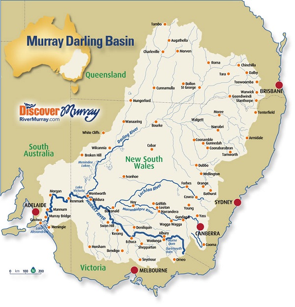
Very little of the Basin is in South Australia.
The Basin consists of 23 river valleys covering over one million square kilometres, 14% or one seventh of Australia. It produces 53% of Australian cereals grown for grain, 95% of oranges and 54% of apples, and supports 28% of the nation’s cattle herd, 45% of sheep and 62% of pigs.
Ecologically it is rich, with around 30,000 wetlands, some RAMSAR-listed, 35 endangered species of birds, 16 species of endangered mammals and over 35 different native fish species.
The average annual rainfall is 530,618 GL, 94% of which evaporates, 2% drains into the ground and 4% ends up as runoff. According to this MBDA site:
-
The Basin receives about 32,500 gigalitres per year (GL/y) of surface water inflows. This includes about 950 GL/y of surface water transferred into the Basin from other valleys mainly through the Snowy Mountains Hydro-electric Scheme.
I think that’s a bit over 6%, but it’s small. The MDBA estimated that baseline diversions (BDLs) for surface water systems in the Basin total 13,623 GL/y.
Going back to the Wikipedia history the original Plan suggested that reducing BDLs by 7,600 GL/y would give long-term ecological sustainability but “would not be socially or economically viable”. The Wentworth Group of Concerned Scientists wanted at least 4000 GL/y. In the end the national parliament decided on 2750 GL/y or up to 3200 if there was ‘no negative socio-economic impact’.
This 2750 figure means:
- Through this process, the MDBA determined that the Basin-wide long-term average SDL for surface water
Groundwater is a separate issue. The MDBA found that the recharge volume of groundwater across the Basin was 23,450 GL/y and the level of baseline diversions were 2,386 GL/y. They found that diversions could increase by 949 to 3,334 GL/y. There are 66 groundwater SDL resource units across the Basin. In only one, the Upper Condamine Alluvium in Queensland, was diversion to be reduced.
It is interesting to look at surface water diversion in relation to the run-off gradient from less than 10 mm in the west to more than 200 mm per annum in the SE:
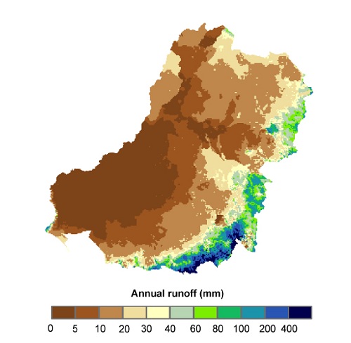
I’m not sure where the boundary is between the northern and southern basins is, but the bulk of the water in the system seems to be in the bottom half. My earlier post says that the Upper Murray catchment alone with 1.4% of the area accounts for 17.3% of runoff. Perhaps that is why the northern part is being targeted with buy-backs of water rights. Certainly the north is hurting – a 21% fall in employment in Collarenebri, 11% in Warren, the prospect of 18% in Dirranbandi and 9% in St George.
Xenophon has succeeded in sending the issue off to COAG. This to some is a cop-out, but he is talking about preventing evaporation in Menindie Lakes and freeing up more water for irrigation and environmental flows. In other words, he wants to revisit the Plan.
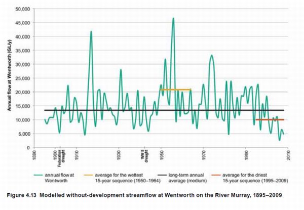
I’d be open to that also. In my earlier post I outlined that the Plan was based on flows, measured at Wentworth, which included the significant decline due the period of the Millennium Drought:
I commented that the plan was for 10 years, and that it considered the effects of climate change would be minimal. This is he last 48 months from the BOM site:
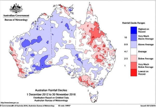
The rain band diagonally across the continent has become stronger since then, but I haven’t any information on stream flows.
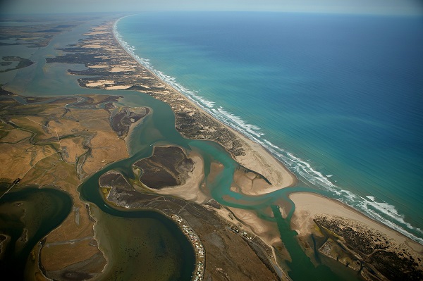
South Australia benefits a lot, especially in the Riverlands and Adelaide town water, but contributes little in terms of water. Much of their concern environmentally is with the Murray mouth, the saltwater environment of The Coorong and the freshwater lake systems around Lake Alexandria.
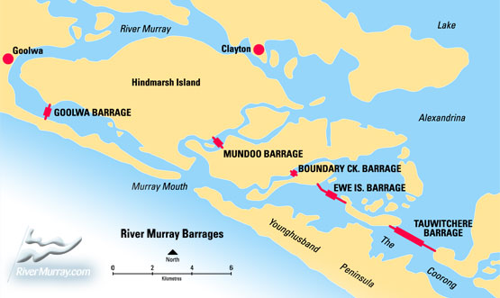
This is artificially kept fresh with barrages and the saltwater systems depend on new water coming through. This is the Murray mouth, which when I first saw it in the 1960s you could throw a stone across. The thin slither of the Coorong stretches into the distance:
This is a diagram of the barrages:
I hate to think what two metres of sea level rise will do, and all the metres which will follow even if we do get our act in order. Inevitably at some time the freshwater systems will be overwhelmed.
River flows exist very much at the margin of the climate in the MDB. We are almost half way through the period covered by the plan. Time once again to be thinking about the future, but an approach which takes into account environmental sustainability, socio-economic considerations and climate change seems even more fraught than it was when the current plan was developed.
One wonders what would happen if the freshwater lakes near the mouth of the Murray went back to being the tidal lakes that existed before SA built all those barrages?
One might also wonder at the economic and environmental impact of using Qld water closer to its source instead of sending it down the Darling River evaporation channel to South Aus?
John, I don’t know how the water in the system is actually measured, but I understand very little if any of the water from Queensland gets to SA. I don’t know much about it, but I believe there are wetlands in northern NSW that would soak up most of it.
The measurement of mas water flows is done in cubic metres per second, ….cumecs or cusecs. So the 450 gigalitres comes out to be around 14.3 cumecs (unles I have lost count of the zeros).
So to appreciate this you need to look at the flow rate (current) and the river cross section. Finding a current for the “Murray” is not leaping out at me, but the river fall over a huge distance is 142 cm per kilometre. To make sense of that you need Mannings equation, and that is why engineers get the slightly bigger bucks. It gets complicated, though very interesting.
One figure I saw for the whole river output was just .9 cumecs, so that says a lot to support the “very little gets to SA” comment.