Tag Archives: Disasters

Saturday salon 18/11

1. The future of humanity

Set aside an hour to listen to the IQ Squared debate on “Humanity is designing its own demise”

Toby Walsh, Professor of Artificial Intelligence UNSW, Signe Dean, science and health journalist, Clive Hamilton, Professor of Public Ethics CSU, and Kristin Alford, Futurist go at it with zest, intelligence and learning.

Unbelievable progress has been made, especially in health and wealth. Among the things I learnt was that we don’t need to fear AI, just the people behind it, and that Elon Musk is actually mad, but will have a colony of 1,000 people on Mars by 2050. Continue reading Saturday salon 18/11

Saturday salon 17/6

1. Towering inferno

A shocker this week was the fire that destroyed the Grenfell Tower in London, a 24-storey building with 120 apartments. The latest count is 30 dead, but the final toll could be much higher as people were incinerated, many difficult or impossible to identify.

Unfortunately people were told to stay in their units, until it became apparent that the fire was spreading up the cladding on the outside of the building – then it was too late for many. Continue reading Saturday salon 17/6

Saturday salon 21/11

1. Brazil dam burst could devastate the environment for years

River Doce translates as “Sweet River”. After two tailings dams burst the focus was on the local town of Mariana, much of which was swept away. Now the concern has shifted to downstream where 500 km of river is becoming biologically dead, the silt is affecting nearby farmlands and is expected to contaminate fishing grounds when it reaches the sea. Continue reading Saturday salon 21/11

Marcia strikes

Mercifully Cyclone Marcia made landfall at Shoalwater Bay, a military training area between Yeppoon and Sarina, south of Mackay. The ABC coverage shows how it zigged and zagged after getting up steam in the Coral Sea:

Marcia_cropped_600

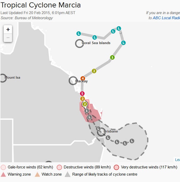
It headed for Mackay and then side-stepped. Perhaps Kolobok Norris was out there on the beach waving his fists! I do hope he and Graham Bell were safe.

It gathered strength to become a category 5, but not nearly as big bad or ugly as Yasi. Nor will it penetrate as far into the inland, where large tracts remain parched.

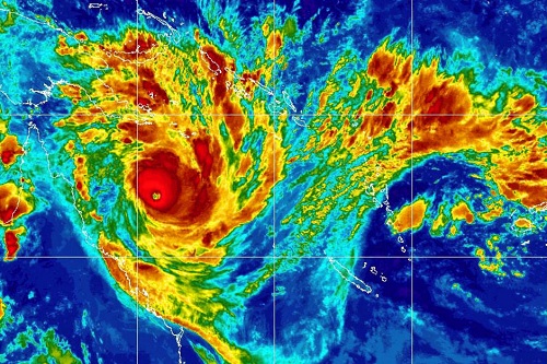
Here’s an image of Yasi:

Yasi 2 Fe 500

Here’s the equivalent of Marcia:

955288-546ca44e-b899-11e4-a901-79cc3d20af7b

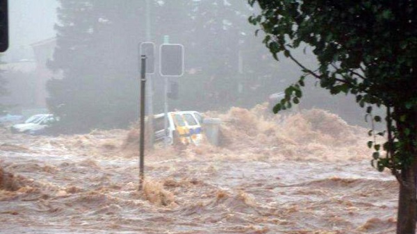
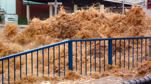
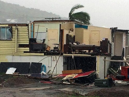
Cat 5 cyclones can destroy buildings. The Courier Mail has a photo gallery, including this:
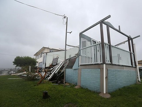
632633-4b486eea-b8c9-11e4-a005-b478f5906d65_500

Here’s another:

675428-218ffec4-b8c9-11e4-a005-b478f5906d65_500

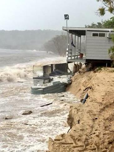
There was a three metre tidal surge and with significant erosion a tourist cabin fell into the sea on Great Keppel Island:

389975-b268ae1c-b89e-11e4-a901-79cc3d20af7b

There will be a lot of personal stories of danger, escape and loss:

603359-0885b52e-b88b-11e4-a005-b478f5906d65

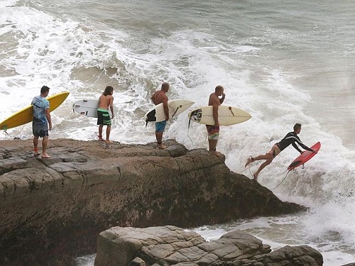
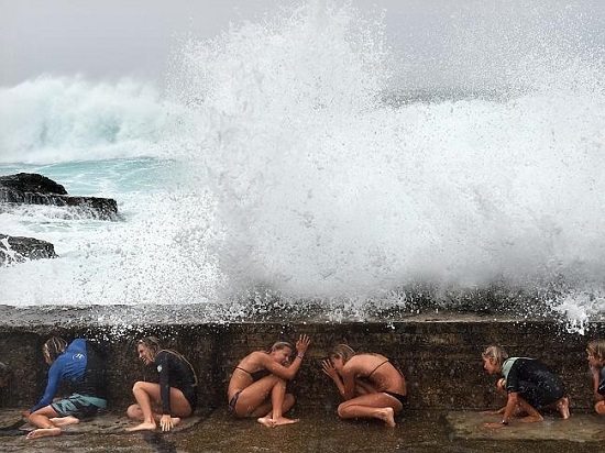
Some people, especially surf board riders, seem to be energised by these events. Here at Noosa they line up for their turn:

611276-4f224e56-b87d-11e4-a005-b478f5906d65_500

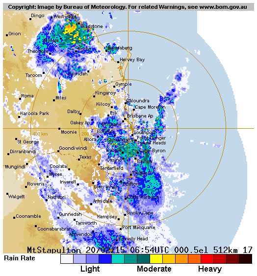
Here in South-east Queensland we’ve had a substantial rain depression for a couple of days. I gather it is related to Marcia but there is clear air between them as seen from this BOM screenshot late on Friday:

IDR661

Considerable swells have already battered then Gold Coast:

760379-478b27bc-b8aa-11e4-a901-79cc3d20af7b_550

Here in Brisbane we await the remnants of Marcia. I gather we are in a 12 hour interval which is like being in the eye of the storm. So far at our place we’ve had about 150 mm or six inches in the old money. We are assured that the main issues will be creek flooding and wind, with the possibility of trees bringing down power lines, hence blackouts and/or blocked roads. We are assured that it will be nothing like the floods of 2011. In fact we may get our reservoirs recharged which currently sit at a bit over 80%.

In the NT Cyclone Lam crossed the coast about 440 km east of Darwin, hitting some remote communities.

At time of posting (2 am) it looks as though Marcia has significantly fizzled and is mainly sliding through to the west of us. We’ve certainly had enough rain and it might do some good in agricultural areas.

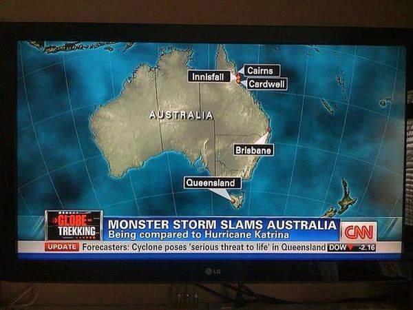
Update: Geoff Henderson has sent me a link to a CNN map shown on Facebook, with Tasmania labelled Queensland. Here it is:

10391411_909890369056003_8292222464971020012_n

Cyclone Haiyan

dn24549-1_300Over the last few days we’ve received a stream of information and images about cyclone* Haiyan which devastated central Philippines, especially the city of Tacloban. Zoe Daniels compiled a graphic report for the 7.30 Report program last night. She mentions that they went to see a coastal village where the devastation was complete.

Here’s a photo from the SMH:

Hayan_ leyte169-408x264

Donations can be made through the Philippine Red Cross and Oxfam. Please feel free to post links to other charities in comments.

According to this link you can donate to the Red Cross by via credit card by phoning 1800 811 700. The hyperlink given there is broken.

Dr Jeff Masters’ Wunderblog has a post which reports the damage initially as $14 billion, breaking The Philippines’ record for damages for the third time in 12 months. Initial estimates of the death toll were put in excess of 10,000, but the SMH suggests the toll from Tacloban alone may have exceeded that figure. Some 9 million people have been affected.

The cyclone has been reported as the strongest ever to make landfall. An article in The Guardian quotes Jeff Masters as putting it at number four with the note that NOAA has stated that the maximum sustained winds estimated for typhoons during the 1940s to 1960s were too strong. The other three were in 1958 and 1961. In his linked post above Masters has compiled an unofficial top ten, with Haiyan at the head. Five of the ten were in The Philippines.

There are two aspects where I’d like better information. Firstly, I heard one report that the wind remained at Category 5 intensity for either six or eight hours (can’t remember which). The system was very large. Secondly, I heard of a storm surge of up to eight metres. Apparently this caused more damage than the wind and was responsible for many of the deaths. In many cases only the lowest areas were evacuated. Continue reading Cyclone Haiyan

A bolt from the blue

As you know I’m always up for a thread of doom, so when I heard talk of asteroid strikes happening more frequently than previously thought I decided to investigate.

The story starts with an asteroid that exploded in the air in the Chelyabinsk region in February 2013. There was a collection of videos at Slate. Car alarms were set off by the shock wave, but I gather most of the damage came from broken glass. Over 1000 people were injured. There are some stills of damage here.

The rock was about 19 metres across (equivalent to a six-story building), with a mass of about 12,000 tons. When it hit the atmosphere at a speed of 20 kilometers per second (many times faster than a rifle bullet) the energy released was equivalent to about 500,000 tonnes of TNT, and the brightness around 30 times that of the sun.

russia_meteor_dashcam2-1506673967.jpg.CROP.original-original_500

This Slate article has a description of what happened physically. Broadly:

It came in over Russia at a low angle, slamming into our atmosphere, violently compressing the air in front of it. That created a vast amount of heat and pressure, which simultaneously melted and broke up the asteroid into smaller fragments. Within seconds, the huge energy of motion of the rock was suddenly and violently dissipated, creating an explosion equal to about 500,000 tons of TNT detonating.

I think 500,000 tonnes of TNT is about the equivalent of 40 Hiroshima bombs.

As that article says (see also the BBC and the ABC) asteroid strikes are now thought to happen more frequently than previously thought (paywalled research here and here), perhaps as much as ten times more. Chelyabinsk-type events were thought to happen every 150 years on the average. Now the estimate has moved to every 25 to 30 years. And then there’s all the others in the range from say 1 to 50 metres. Previously we relied on visual records, but some, over the sea, for example, have escaped notice.

Apparently there are literally millions of objects in the tens-of-metres-of-size range that could come near Earth and we only know about 1000. Continue reading A bolt from the blue

Quicklink: Roger Jones on Bolt on Bandt

NSW fires_250Adam Bandt recently wrote an opinion piece in The Guardian suggesting a link between the NSW fires and climate change, then suggesting that the Abbott Government’s action, or lack of it, on climate change has real implications for loss of life. This incurred the displeasure of one Andrew Bolt who, inter alia, quotes or rather misquotes Roger Jones.

Roger takes a look at these doings at his blog Understanding Climate Risk.

It turns out Bolt is the one who is wrong, wrong, wrong. Oh, and a disgrace, but we already knew that.

Update: Roger Jones has two more posts up:

Fire and climate change: don’t expect a smooth ride

Backburning

Oklahoma tornado and climate change

Tornado damage_cropped_300

The Courier Mail had quite a good piece. If you want pics the BBC has a gallery or enter Oklahoma tornado at Google images. There are some videos collected here. The Courier Mail has a large photo gallery.

Climate Progress revisits tornadoes, extreme weather and climate change. The bottom line is that the jury is out.

In the US tornado alley warm moist air flows north from the Gulf of Mexico in the lower atmosphere and becomes unstable. Dry, cold air comes from the west over the Rockies in the upper atmosphere, with a shear effect to create the top of the column. The warm air becomes unstable and lifts. The shear effect of the upper wind spins the rising column. More air is sucked in by the spinning, rising column. That’s simplistic but those are the basic elements as I understand them.

With climate change the lower atmosphere warm air flow and instability are likely to be enhanced, but there could actually be less wind shear. We don’t know what the result of those factors will be over time, but the suggestion is that if anything there have been fewer severe tornadoes over recent decades. Continue reading Oklahoma tornado and climate change

Remembering the floods

As I write we have brutal heat in Brisbane, with a dry west wind. On 11 January last year Robert Merkel put up a post, Queensland floods get worse. Later that day Mark put up a post, Brisbane flood maps and up to date flood information and slaved mightily for a time passing on information gleaned from twitter and other sources, until he went quiet. By the 12th he was a refugee at my place. His place was high and dry, but the power went off. By the 14th the Brisbane floods were in retreat.

Earlier on the 10th there had been what we used to call a ‘cloudburst’ on the Toowoomba Range, when 150mm (6 inches in the old money) fell in about half an hour. I posted some Toowoomba flood pics taken by my cousin’s brother-in-law. Yesterday I heard Anna Bligh tell the story of a year ago, how she was addressing the umpteenth press briefing on the Queensland floods. From September 2010 there had been many cities and towns flooded across Queensland, some of them totally evacuated several times. As she fronted the media a minder handed her a sheet with breaking news. She found herself talking about swift water rescues in the main street of Toowoomba. “This can’t be right”, she thought. “It’s impossible.” It wasn’t. This is what was going on in Toowoomba:

Toowoomba flooding
Raging floods in Toowoomba

Continue reading Remembering the floods

Open thread on floods

We now have a number of specific threads running on aspects of the Queensland floods. This thread is for comments that don’t fit the specific threads or if you want to comment on other current floods lacking a thread, such as those in Victoria, Brazil or Sri Lanka .

These are the previous threads I can identify:

Brian on Queensland floods

Robert on Queensland floods get worse

Mark on Brisbane flood maps and up to date flood information

Brian on Toowoomba flood pics

Brian on Brisbane floods in retreat

Kim on Political cheap shots and the Brisbane floods

Kim on Quick link: Quiggin on water policy after the Queensland floods

Kim on Quicklink: Interactive map of Brisbane flood damage

Kim on Germaine Greer wrong on Brisbane floods

Mark on Social capital, social networking and the Brisbane floods

Hope I haven’t missed any.

Brisbane floods in retreat

The flood clean-up begins as the river retreats.

The swollen Brisbane River has dropped to 2.7 metres and emotions are running high as residents start returning home to survey the damage caused by yesterday’s flood peak.

About 26,000 homes had either major or partial flooding when the river peaked at 4.46 metres.

Weather bureau senior hydrologist Jess Carey says the river system has fallen to 2.7 metres but will rise again to about 2.85 metres this morning.

“It’s certainly been dropping fast. It’s been expected,” he said.

He says the Bremer River is also falling quickly at Ipswich where 3,000 homes were flooded.

Continue reading Brisbane floods in retreat

Toowoomba flood pics

The main purpose of this post is to share some photos sent to me taken by my cousin’s brother-in-law in Toowoomba. But first some context.

Paul Norton described the topography of Toowoomba thus:

    Just to give people some idea of what seems to have happened in Toowoomba, the city of Toowoomba is located just on the west side of the Great Dividing Range. As you travel from Brisbane to Toowoomba, the road begins climbing slowly after about Grantham and Helidon, then climbs steeply west of Withcott before cresting the range at a bit under 700 metres. The eastern suburbs on Toowoomba are built on the western slope of the range, whilst the CBD is located in something of a hollow at the bottom of this slope, with gentler slopes to north and south. The “cloudburst” (to used Brian’s word on the older thread) on the range looks to have basically been funnelled into the CBD by the topography.

    Further to my previous comment, the range forms a neat half-circle around Toowoomba on the east side, centered on the CBD.

Continue reading Toowoomba flood pics