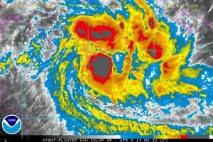
 As Cyclone Ita bears down on the coast of Far North Queensland I was reminded of the post I drafted in late February on extreme weather. Ita is rated as category 4, hence severe. On the upside few people live in the expected path. On the downside the people who do are not likely to get much help from the outside world.
The incidence of cyclones is not expected to increase with climate change, although I understand the story could be different in the Caribbean and the NW West Pacific. However, we are likely to get more severe cyclones and they may be more intense.
Here’s the post as I wrote it.
This summer, Australians again endured record-breaking, extreme heatwaves and hot weather. My daughter in Adelaide, for example, experienced a record 13 days of 40°C-plus maximums. The Climate Council’s latest report Heatwaves: Hotter, Longer, More Often came up with four key findings:
First, climate change is already increasing the likelihood and severity of heatwaves across Australia. Second, heatwaves have widespread impacts including increased deaths, reduced workplace productivity, damage to infrastructure such as transport and electricity systems, mortality of heat-sensitive plants and animals, and stress on agricultural systems. Third, record hot days and heatwaves are expected to increase further in the future. And finally, limiting future increase in heatwave activity requires urgent and deep cuts to greenhouse-gas emissions.(Emphasis added)
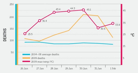
While the 2009 Black Saturday bushfires killed more than 170 people, the preceding heatwave killed double this figure. In fact heatwaves kill more Australians than any other natural disaster, a fact largely unremarked. The following graph plots 2009 deaths against temperature and the 2004-08 average.
According to the report it has been estimated that heatwaves could cause an additional 6214 deaths in Victoria alone by 2050.
Adelaide’s heatwaves are an average 2.5°C hotter than they were half a century ago, and peak heat days are 4.5°C hotter.
Hot days, previously considered to be “once-in-20-years” occurrences, will start to happen every two to five years in Australia by mid-century.
At the end of the report they return to their constant theme – this is the critical decade in which to take action.
Meanwhile in Toronto where my sister lives they had an ice storm around Christmas and have been living in below zero temperatures ever since (time of writing, 19 February). The snow shovelled from their driveway doesn’t melt, so the pile goes up and up and up. Of the cities listed on the weather page of our local rag only Montreal has been consistently colder.
(Update: I think the cold spell lasted at least another month.)
At the same time weather historian Christopher C Burt blogged about record warmth in Alaska.
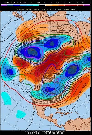
He shows an amazing map of the forecast for February 1st at the end of the post. It’s stunning, showing the Northern Hemisphere weather split by a stream of warm air directly across the North Pole:
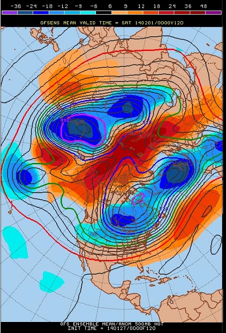
There is a related post at Dr Jeff Masters’ Wunderblog he says:
The cold air flowing out of the Arctic into the eastern half of the U.S. is being replaced by warm air surging northwards over Alaska and the North Atlantic east of Greenland. The warmth in Alaska the past three days has been particularly astonishing, with Alaska observing its all-time warmest January temperature of 62°[F] on Monday 1/27 at the Port Alsworth Climate Reference Network station, according to Rick Thoman of NWS Fairbanks. This ties the January state record set at Petersburg on January 16, 1981. Port Alsworth is about 160 miles southwest of Anchorage.
Nome, Alaska recorded a high of 51°F [10.5°C] on Monday. This was 38°[F] above average, and the warmest temperature ever observed in any November through March in Nome since record keeping began in 1907. (Emphasis added)
I think 38°F is about 21°C.
Elsewhere I’ve read that the US and Canada were 5°C colder than the 1951-1980 base in December, while north-eastern Europe and Siberia were 9°C warmer. Berlin and Moscow seem rather balmier than usual.
We are normally told that the jet stream has slowed down but for a time in February it speeded up, while being stuck in one place. The effect of this was to fling low pressure systems at the UK, where they experienced record floods.
Back in Oz again, much of the country is in severe drought, although, ironically, the grand tour by Abbott and Barnaby Joyce into the drought areas was interrupted by rain. Of course, one dump of rain doesn’t necessarily break a drought and the prospect for the coming 2014-15 summer is 75% stacked in favour of an El Niño. More records could be broken, including global average surface temperatures.
During this critical period of necessary climate action the Abbott government has appointed a climate denier Dick Warburton to head up the review of the Renewable Energy Target.
We live in interesting times.
PS One of my favourites from the archives is Remembering the floods.